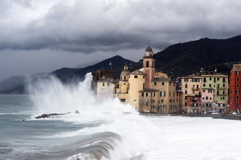
Sea level rise may be higher than previously thought, according to a study
Researchers have reviewed nearly 400 scientific articles related to sea level rise and associated risks and concluded that most studies may have underestimated global sea level rise by an average of 0.3 meters. In some areas of the Global South, these levels could be up to 1 meter higher than previously thought. According to the authors, a reassessment of the methodology used to characterize the impact of sea level rise is necessary, as this could have implications for policy, climate finance, and coastal adaptation plans. The study is published in Nature.
260304_Xavier Rodó_nivel del mar
Xavier Rodó
ICREA research professor and head of ISGlobal's Climate and Health programme
The article has good standards given that it handles a multitude of data—albeit from a meta-analysis, which always raises some doubts and increases uncertainties and the possibility of errors because the studies are not similar in their methods—and the methodology is solid, simple, and clear.
The implications are significant, as the authors themselves point out, since it changes the previous level of confidence about the effects of global warming on sea level rise, both globally and at the regional and local levels. In the latter case, for the global south, where fewer direct measurements of actual coastal levels have been made and, therefore, there is less data, the discrepancies between the most widely used geoid model and actual measurements are greater, with a difference of one metre or more.
This fact — that globally the average has to be repositioned about 30 cm higher, reaching a level of several metres in extreme cases in Southeast Asia — means that many more coastal cities and more people living there will be affected by changes such as those predicted by global models. In other words, there will be less time to have a greater impact, which is worrying as these regions are in LMICs (Low and Middle Income Countries), with little capacity to adapt to changes or mitigate their effects.
In Spain, the approximation of geoids is better, as is the case in other European countries with coastlines or in North America, as data records are much better and discrepancies are minimal. There is no substantial impact of this study in the sense that it will change the sea level rise projections that have already been published.
I believe that the margin of error in the methodological adjustments they propose, and therefore in the estimates made, will be greater precisely in those areas where the discrepancies are greatest: basically the different coastal regions of Asia, East Africa and Australia, but also the Pacific and in particular the South Pacific. However, it is a good study, very necessary, and one that further refines the range of future projections for sea level change on the different coasts of the planet.
Hare - mar
Bill Hare
CEO, Climate Analytics
This is a groundbreaking piece of science that has clearly taken some years to put together and is extremely robust. This paper brings some profound bad news to the assessment of sea level rise and coastal impacts. It essentially shows that most previous assessments of the impacts of sea level rise based on satellite data have likely systematically underestimated exposure to severe risks as well as the rate at which these risks will increase in the future.
Very substantial progress has been made in projecting sea level rise in recent years, most of which has shown that sea level rise is likely to be higher than previously thought. Previous research was already showing we are at major risk of sea level rise of up to one metre by 2100. This new science shows that the projected impacts from SLR are likely to be much higher than previously thought. And extra risk of damage is much greater than previously forecast, particularly in the most vulnerable countries, especially small island states, low lying developing countries and the large archipelago of Southeast Asia.
The methods and results in this paper appear quite robust and challenge sea level rise impact assessments based on satellite data. The geoid method that has been used historically worked very well in the global north where most research has originated. But few were aware that in other parts of the world, this method has been producing very large discrepancies.
Based on the evaluation made from literature, it is clear that the impacts of this underestimation of satellite-based sea level rise impact assessments are very large and very significant. This is particularly true for the developing countries where the gap between sea levels estimated by land or sea is the largest. We have always known that sea level rise is a relative phenomenon – sea levels do not rise evenly across the world and in some places will go down. Properly estimating sea level rise impacts requires taking into account the position on the Earth, and whether or not land is rising or subsiding – often due to human effects.
The results here could add a staggering new dimension to sea level rise impact assessments – particularly given that many impact assessments cited by the authors as underestimations have been used to guide coastal impact, vulnerability and adaptation risks and measures. The two regions where the gap in estimation is the largest, Southeast Asia and the Pacific, are home to many Small Island Developing States (SIDS) and Least Developed Countries (LDCs), which were already the most vulnerable to the impacts from sea level rise and other climate impacts. The paper identifies low-lying atoll countries in the Pacific as places where the assumed sea levels are lower than actual measurements (in two out of three scenarios). Under these new circumstances, they will face increased vulnerability and likely higher costs to deal with adaptation and minimise the impacts of disasters. The urgency to mitigate emissions to minimise sea level rise impact and improve access to finance for adaptation and loss and damage is ever clear.
Germany and Northwest Europe, according to the authors Figure 3 are amongst the least affected globally. The largest number of people affected are in the Global South.
Given the significance of what has been discovered there needs to be an urgent program to review, and reanalyse and assessments to determine is coastal adaptation strategies need to be updated and timelines expedited.
The study argues for the application of new methodologies based on their findings. The authors themselves make clear that this does not mean that the majority of the evaluated studies make errors, or that the IPCC reports that cite these studies are wrong or are containing errors. This is important to bring across in the reporting. Otherwise the study may be misused to disqualify previous insights on SLR or the scientific process as a whole, undermining the basis for climate action.
This study is part of the scientific process in which the evidence base on climate change, impacts and risks continues to evolve based on new evidence and methodologies. If anything, this new assessment is in line with other new findings in relation to climate change, where risks are increasingly being assessed to occur sooner than previously estimated.
This is not a matter of disqualifying the science so far, but a further line of evidence that shows that we must err on the side of caution when it comes to climate impacts and act sooner rather than later to curb adverse impacts, of which SLR is one of the most severe.
Palmer - mar
Matt Palmer
Science Fellow at the Met Office Hadley Centre and Associate Professor at the University of Bristol
This is a very important paper that finds widespread underestimation of the coastal flood impacts associated with projections of sea-level rise. On average, the height of sea level is underestimated by 0.3m, which represents a large fraction of the projected rise to 2100.
Of even greater concern is the underestimation of sea-level height by up to 1m in the Global South, where huge coastal populations live alongside the threat from extreme waves and storm surges.
This means that the impacts of sea-level rise under climate change have been systematically underestimated. Put another way, we could see devastating impacts from coastal flooding earlier than expected from climate projections - particularly in the Global South.
The paper raises important questions on the need for interdisciplinary expertise and guidance in sea-level rise impacts assessments. The work also suggests a need for more comprehensive world-wide sea level observations to anchor future impacts modelling.
Bamber - mar
Jonathan Bamber
Director of the Bristol Glaciology Centre, University of Bristol
Sea level rise (SLR) is one of most serious and certain consequences of global heating. It is a field I have worked in for some two decades and I was genuinely surprised by the results of this study, which is not about reassessing how much SLR there might be in the future but about using the correct estimate of present-day sea level. This might seem obvious, but unless practitioners and others working in the field understand the nuances of the different types of reference surfaces used and how they relate to coastal sea level it is easy to miscalculate the offset between coastal elevation and the sea surface height in that location.
What the authors demonstrate is that in the majority of impact studies, that is exactly what has happened. The wrong assumptions are made about what present-day sea level is and it turns out that it has generally been underestimated in key sensitive coastal areas. This has important implications for impacts of future SLR in terms of the area and number of people potentially affected in low lying areas such as south east Asia and the Nile delta. It does not affect how much SLR might occur in the future.
The authors estimate that the offset between the true sea surface height and that used in impact studies is around 24-27 cm. To put that in context, that is more than the total SLR that has occurred since the beginning of the 20th century. They highlight an important limitation in most coastal impact studies but their conclusions about how this will affect estimates of future coastal inundation are less certain. First, they assume a higher accuracy for estimates in mean sea surface height at the coast than is actually the case. The best way to assess this is against tide gauge data, which are actually located at the land/ocean boundary. Second, the elevation of the land surface in the coastal zone has relatively large errors, which compounds the difficulty in determining the relative difference between the height of the land and sea at the coast.
Conflicts of interest: Jonathan Bamber “is a professor of Earth Observation and glaciology at the University of Bristol and a visiting fellow at the Technical University Munich (TUM) and receives funding from the European Space Agency on a study aimed at closing the sea level budget globally and regionally. He also receives funding from TUM on coastal sea level and the EU on glaciers and ice sheets.”
Seeger and Minderhoud
- Research article
- Peer reviewed