Weather forecasts warn that El Niño could return this year with greater intensity
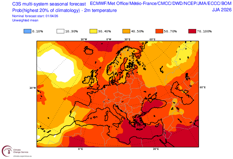
The latest forecasts from the European Centre for Medium-Range Weather Forecasts (ECMWF) suggest that there is a likelihood that the phenomenon known as El Niño will return this year and that it will do so with greater intensity. In Europe, for June through August, the forecast indicates a slight tendency toward below-average precipitation in the northeast of the continent. As for the Iberian Peninsula, temperatures are expected to exceed the top quintile of the seasonal average. Although it is not yet certain that this will occur, forecasts for the coming months will either confirm or rule it out.
Javier Martín-Vide - El Niño
Javier Martín-Vide
Professor of Physical Geography at the University of Barcelona, Director of the Fabra Observatory RACAB
La Niña, which has been weak, has ended, and we are now in a neutral ENSO phase until the start of the northern hemisphere summer. Then, most likely, El Niño will arrive (a warming of the waters of the equatorial Pacific and, progressively, of the coastal Pacific waters off Ecuador, south of Guayaquil, Peru, and north-central Chile; and the retreat of the tropical anticyclone from the South Pacific). Once El Niño is established, it would last for the remainder of 2026. There is, however, a certain probability—not very high, but significant—that El Niño will reach the category of intense or very intense. This is being cautiously announced by the Climate Prediction Center (NCEP/NWS) of the U.S. NOAA. Their predictions are highly reliable.
Rubén del Campo - El Niño
Rubén del Campo
Spokesperson of the State Meteorological Agency (AEMET)
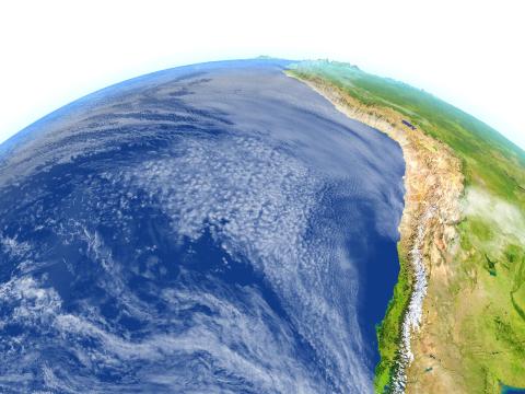
The first thing to note is that the phenomenon known as the “Superniño” is not a scientific term. This more journalistic name, “Superniño,” is typically applied to an El Niño event in which sea surface temperature anomalies in a specific region of the Pacific—known as the El Niño 3.4 region—exceed 2 degrees. El Niño is a natural phenomenon in which the waters of the equatorial Pacific Ocean, particularly in its central and eastern parts, experience a rise in temperature until they reach abnormally high levels.
It is generally considered that when the temperature in this area of the Pacific rises more than one degree Celsius above normal, an El Niño event is underway. When this happens, especially if the phenomenon interacts with the atmosphere, it can alter weather patterns and lead to unusual weather conditions. For example, it can increase rainfall in parts of South America, intensify droughts in the Caribbean, or result in fewer hurricanes than usual in the Atlantic. Right now, based on the latest forecasts, there is about a 60% chance that El Niño will develop by the start of the Northern Hemisphere summer, that is, beginning in June.
This phenomenon could intensify further, and it cannot be ruled out that by late summer or early fall we might experience a very strong episode, what some media outlets call a Superniño. Right now, the probability is approximately 25% for late summer or early fall. In any case, we are still at a stage where the predictability of the phenomenon is not at its highest, and it will be better confirmed in the May forecast update and, of course, in June.
There is still some uncertainty. What are the reasons this Superniño would occur? As I said, because sea surface temperature anomalies in the region would reach values above 2 degrees. This anomalous warming usually occurs due to various circumstances, but it all starts with a weakening of the trade winds that blow in that area.
They originate from the northeast in the Northern Hemisphere and from the southeast in the Southern Hemisphere, and since they are constant winds, they stir the waters, bringing up deeper waters, which are colder, and that is why temperatures are generally lower when there are trade winds. When these trade winds die down, those waters do not rise to the surface. Furthermore, with no wind blowing, the surface water gradually warms until a sufficient anomaly is reached to qualify as El Niño. If the phenomenon persists and remains intense, it can lead to a very strong event, with temperatures exceeding a 2-degree anomaly.
In this regard, it should be noted that there is no direct correlation between the occurrence of El Niño and the type of weather we can expect in Spain. There is a lot of talk about a significant rise in temperatures, but it must be emphasized that when this is discussed, it refers to temperatures on a global scale. We must consider that during an El Niño event, there is a large amount of ocean water that is warmer than normal, and this causes global average temperatures to rise. Therefore, by the end of this year or early next year, if the El Niño phenomenon persists, on a global scale we could be looking at an additional fraction of a degree on top of the baseline warming we are experiencing due to anthropogenic causes.
In other words, the greatest warming of our planet is clearly being caused by greenhouse gas emissions, but this natural El Niño phenomenon could add a few tenths of a degree by the end of this year or early next year. But for Spain, I insist, there is no clear correlation. Certainly, there is no reason for one to exist for the summer.
It could be an extremely hot summer, whether El Niño has developed or not. The two hottest summers we’ve had in Spain so far—2022 and last year—were both extremely hot, and there was no El Niño phenomenon. Therefore, a correlation cannot be established.
It is true that some studies suggest that when there is an intense El Niño phenomenon, we may also experience a rainier fall on the Iberian Peninsula. There may be some correlation in that sense. But it should be noted that an El Niño event does not always result in a rainier-than-normal autumn in Spain, and a rainier-than-normal autumn in Spain is not always due to an El Niño event.
So, in that sense, the uncertainties are still very high.
Anna Cabré - El Niño vuelve EN
Anna Cabré
Climate physicist, oceanographer and research consultant at the University of Pennsylvania
The Spring Barrier makes it more difficult to predict a Super Niño during the spring. As summer approaches, scientists will be able to provide more accurate forecasts. For Spain, the implications of a Super Niño could include extreme heatwaves, changes in rainfall patterns, and adverse effects on agriculture and biodiversity.