What is the relationship between the DANA and climate change?
The devastating effects caused by the DANA over the peninsula and the Balearic Islands in large parts of the Mediterranean area, especially in the Valencian Community and some regions of Andalusia, are a wake-up call on the relationship between these extreme events and climate change.

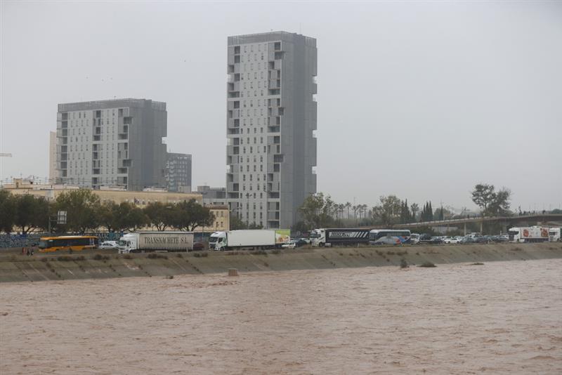
General view of the new Turia riverbed next to the V-30, which is blocked as it passes through the La Torre neighbourhood in Valencia, one of the southern suburbs suffering from flooding as a result of the heavy rains of the last few hours. EFE/Manuel Bruque.
Ernesto Rodríguez - DANA EN
Ernesto Rodríguez Camino
Senior State Meteorologist and president of Spanish Meteorological Association
What relationship can we say that this type of event has with climate change?
‘In general terms, what we know is that, in a context of climate change, these types of intense and exceptional, rare rainfall events are going to become more frequent and more intense and, therefore, destructive.
That is in general terms. Events of this type, which used to occur many decades apart, are now becoming more frequent and their destructive capacity is greater.
Associating a particular event like this to climate change, i.e. asking the question that if we had not had climate change we would have suffered an event like this, requires a posteriori studies and can always be said in probabilistic terms, but not on the fly. This is something that will be analysed and these very destructive or very violent cases, then give rise to many studies that are done in academic and research fields'.
We can't say anything on the fly, except that in a context of climate change, these types of events will be more frequent and more intense’.
What role do warnings play in these extreme events?
‘What we have to bear in mind is that warnings are issued for relatively large areas, at the county level, and then the most extreme consequences are at the point level, often at the municipality level, and this depends on many other things that have nothing to do with precipitation.
The warnings issued by AEMET refer to precipitation, which is AEMET's responsibility. But whether that rainfall then has more or less destructive effects also depends on the orography, on rainfall upstream, on public works, on where the municipalities are located, on whether there are obstacles or not.... All of this is something very particular. Between heavy rainfall and its destructive power, there is a whole chain of actions that must also be considered'.
María José Sanz - DANA EN
María José Sanz
Scientific Director of the BC3 Basque Centre for Climate Change
Attributions are always tricky. Generally speaking, the jet stream, because of the changes we are seeing, due to climate change, is having more pronounced undulations. DANAS are areas of low pressure that are isolated from the jet stream. Although they are frequent, they happen more in winter, when these undulations occur.
In addition, as we have more water in the atmosphere right now because the oceans are warmer due to the increase in temperatures, this factor is added to the previous one and causes intense phenomena.
We will have to see what conditions have occurred, where this isolation of low pressures has taken place or the amount of evaporation, among other issues.
There are also atmospheric rivers, certain currents in the atmosphere that transport water vapour. There are studies that indicate that extreme phenomena in California were related to this factor.
Liz Stephens - DANA Valencia
Liz Stephens
Professor in Climate Risks and Resilience, University of Reading
People shouldn't be dying from these kinds of forecasted weather events in countries where they have the resources to do better.
While a red weather warning was issued for the region with sufficient time for people to move out of harm's way, a red warning alone doesn't communicate what the impact will be and what people should do.
Climate scientists have been warning for years that climate change will lead to more intense rainfall, and the tragic consequences of this event show that we have a long way to go to prepare for this kind of event, and worse, in future.
Jess Neumann DANA Valencia
Jess Neumann
Associate Professor of Hydrology, University of Reading
The flash floods in Spain are another terrible reminder of the changing and more chaotic weather we are experiencing as a result of climate change.
“The storms have developed as a result of cooler air passing over the warm Mediterranean ocean, creating atmospheric instability and bringing with it torrential rain. These types of storms can develop quickly and with relatively short warning.
Local communities have reported walls of water up to three meters high. The loss of life shows us that we are not fully prepared to deal with storms like those that have hit southeastern Spain.
We need to give serious consideration to how we can better design our landscapes, towns and cities. In the longer term, this will need to include radical redesign of urban areas.
Flash floods can affect anyone, anywhere. We take preparation for other hazards such as earthquakes and tsunami very seriously with education, drills, and emergency kits. It is time we afforded the same to flood risk preparedness.


