Reactions to the high temperatures expected for the next few days in the Iberian Peninsula and the Balearic Islands
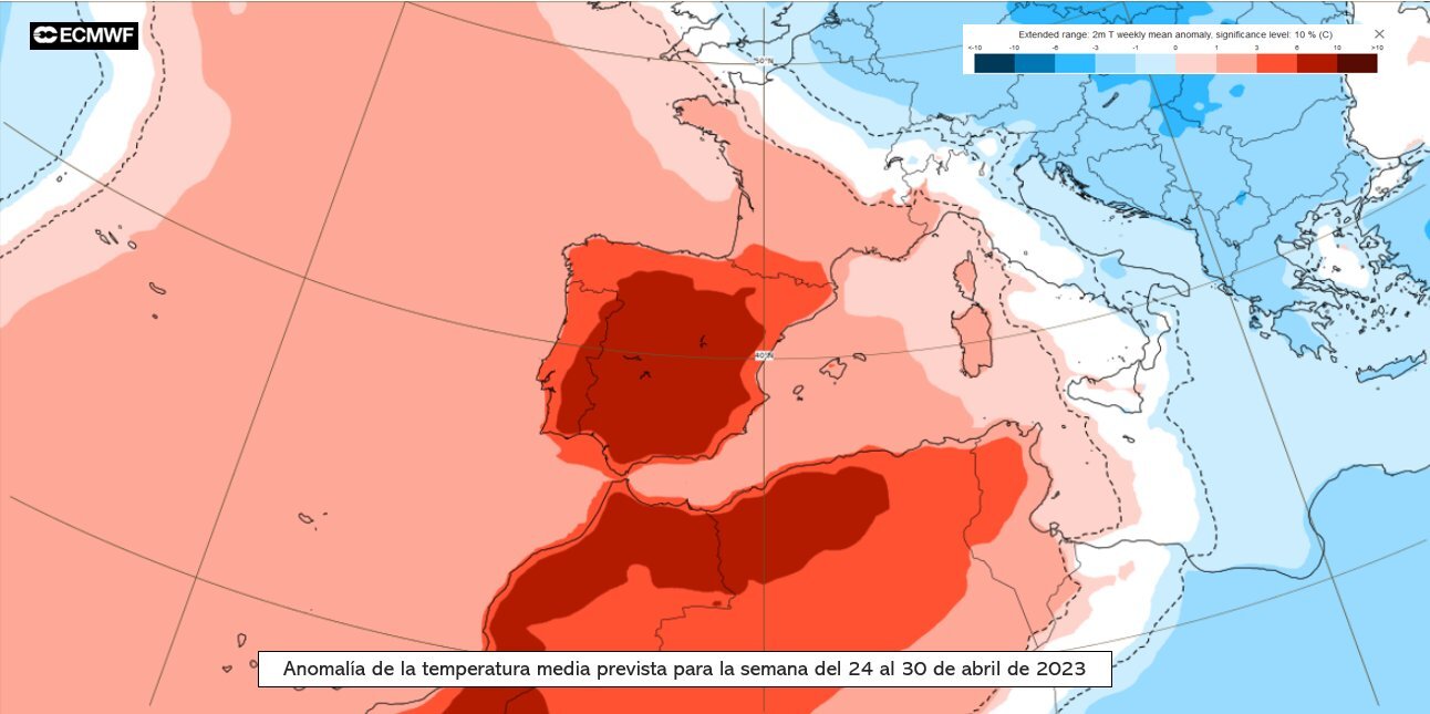
The State Meteorological Agency (AEMET) has reported that, from Tuesday, the progressive entry of a mass of very warm and dry air of African origin over the peninsula and the Balearic Islands will cause exceptionally high temperatures for this time of year, with values typical of summer. According to AEMET, during Thursday 27, the threshold of 30 ºC is likely to be exceeded throughout the southern half, as well as on the banks of the Ebro. On the other hand, 35 ºC is likely to extend to the Guadalquivir valley in Córdoba and Jaén. During Friday it is possible that 35 ºC will be exceeded in the banks of the Ebro in Zaragoza and other points of the southern half, in addition to the Guadalquivir valley, where the maximum temperature values could be around 38-40 ºC.

Marc Santandreu - calor abril EN
Marc Santandreu
Physicist and meteorologist at RTVE
The temperatures of this last week of April are totally exceptional. Although it would be more 'normal' to see them in July and August, even there they would fall within the high range for the season. That is, they would be typical for a very hot summer day. If the forecasts are fulfilled, we expect to break temperature records in many capitals. And not by tenths, but by a long way. An intense and extensive heat that will also move after sunset, with tropical nights expected in different municipalities. It should be emphasized that this episode is attributed to an exceptionally warm air mass for the season, and not to local and orographic effects that are sometimes capable of triggering temperatures in certain areas. Hence its extent and intensity.
It is important to speak clearly about this type of episodes. This is climate change. Of course, a subsequent attribution study will have to be carried out to see how much it is linked to global warming, but undoubtedly, without anthropogenic forcing, we would be talking about much more moderate values.
This, which is now something strange, which is news, will unfortunately cease to be so in a few years. Because we will get used to it, because having happened before, it will not be talked about.
Everything that is happening is consistent with climate change projections, as was the case last summer and as will be the increased frequency of these extreme events in the future.
Ricardo Torrijo - calor abril EN
Ricardo Torrijo
Meteorologist of the National Forecasting Center of AEMET
The high temperatures forecast for Thursday and Friday of this week in various parts of the peninsula are not at all a usual situation for this time of year. It is something very unusual and records may be broken in several stations. Particularly striking are the high values that could be reached in the Guadalquivir valley. However, there is still some uncertainty in the temperatures that can be reached, so we will have to wait to see what happens to make an assessment.
On the other hand, regional projections for Spain, made by AEMET specialists, based on internationally recognized global models, point, for the coming decades, to a progressive advance of summer and a more marked rise in temperatures in this season, and with a greater number of heat waves.
It is possible that we are on the verge of the first heat warnings of the year. In the face of warning situations, including those due to heat, we recommend the population to be informed of the weather situation, to follow the advice of Civil Protection and to act with prudence and common sense. And not only because of the effects of the heat; the risk of fire is also very high and citizens should be asked to exercise extreme caution. Finally, the UV radiation index is very high, which has nothing to do with the heat, but with clear skies. However, the heat encourages people to wear less clothing and do more outdoor activities, so we also urge caution against overexposure to the sun.
Ernesto Rodríguez - calor abril EN
Ernesto Rodríguez Camino
Senior State Meteorologist and president of Spanish Meteorological Association
The announcement by AEMET of the abnormally high temperatures for this time of the year expected for the next few days is consistent with the effects of climate change repeatedly announced by scientific bodies, mainly represented by the Intergovernmental Panel on Climate Change (IPCC). This group, in its most recent synthesis report of the sixth assessment cycle, insists and reiterates that the occurrence of more frequent and intense extreme weather and climate events - especially those related to temperatures - is one of the most easily perceptible consequences of climate change caused by our uncontrolled greenhouse gas emissions.
The climate change projections calculated by a multitude of research centers and compiled and disseminated in the IPCC reports represent the script of how the climate and its impacts will evolve for different greenhouse gas emission paths. The higher the emissions, the greater the warming of the climate system and the greater the effects such as the occurrence of more frequent and intense extreme weather and climate events. These temperature records, which are expected to be broken in the coming days, and in the absence of the necessary attribution studies to be carried out a posteriori, do not deviate one iota from the script written in the form of numerical simulations and summarized and disseminated by the IPCC. Moreover, the IPCC insists that there is still time to set the climate right with sustainable, decisive and sustained action. If we do not take these measures, the climate will continue to change and effects such as these extreme events will become more and more common and will hit us harder.
Of course, in addition to tackling the causes of climate change by reducing our collective greenhouse gas emissions, we must adapt to the effects of climate change that are already affecting us. One of the most effective ways of adapting is to take measures in the face of extreme phenomena that are easily predictable over the horizon of days and that may affect the most vulnerable sectors of the population and certain socioeconomic sectors. The warnings that are disseminated and the measures that are put in place every time an extreme heat episode appears are a very good example of adaptation to climate change and its effects.


